


Page 31 - 2417
P. 31
Chaib et al. Carbon Footprints 2026, 5, 23                                        Page 7 of 23


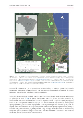
               Figure 3. Project area (Curiaú) and reference region, including Quilombola territories and settlements filtered according to SCM0011
               robustness criteria, and natural forest formation (2022) used for baseline construction. Data sources: Base imagery from Google Earth
               (Google Satellite imagery), accessed November 2025 (https://earth.google.com); Land-cover data from MapBiomas Brazil Collection 10
               (10 m resolution) (https://brasil.mapbiomas.org); Quilombola territory boundaries from Instituto de Terras do Amapá (ITER-AP);
               Settlement areas from INCRA - National Institute for Colonization and Agrarian Reform (https://www.gov.br/incra); Map prepared in
               QGIS v.3.42.1 using the SIRGAS 2000/UTM Zone 22N coordinate system.


               Nacional de Colonização e Reforma Agrária (INCRA), and the boundaries of other Quilombola
               communities and agrarian-reform settlements were obtained from the Sistema de Informações de Projetos
               de Reforma Agrária (SIPRA) and related INCRA public datasets.


               Natural forest formations and anthropic land-use classes were defined following the MapBiomas legend and
               the reclassification rules  [Figure 3]. Natural forest area was mapped for the year 2022, which represents the
                                   [42]
               baseline observation year adopted in this study, consistent with the subsequent assessment of
               forest-to-anthropic transitions in 2022-2023 and with the reference period captured by the livelihood
               vulnerability survey. The project area was defined as the largest contiguous block of natural forest within the
               officially demarcated Curiaú territory; other land uses and smaller forest fragments inside the legal boundary,
               including additional forest patches and agricultural areas, were not included in the project polygon but
               remain part of the recognized Quilombola territory. All spatial data were harmonized in a projected
               coordinate reference system suitable for area estimation.

