


Page 35 - 2417
P. 35
Chaib et al. Carbon Footprints 2026, 5, 23                                       Page 11 of 23


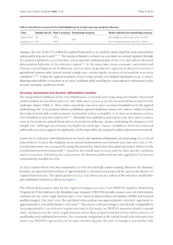
               Table 3. Classification accuracy for the 2022 MapBiomas 10-m land-cover map and global reference
               Class     Sample size (n) User’s accuracy Overall map accuracy  Global reference for overall map accuracy

               Natural forest 100     98%                                   ESA WorldCover 10 m 2020 v100: 74.4% [58]
                                                  94%
               Anthropic use 100      90%                                   Esri 10 m land use/land cover 2020: 75% [59]

               changes, the role of the LVI within the applied framework is to establish initial eligibility and contextualize
               additionality at project entry [43,52] . The temporal dynamics of land-use outcomes are instead captured through
               the annually updated ex post baseline, which operates independently of the LVI and reflects observed
               deforestation behavior in the reference region . At the same time, socio-economic constraints and
                                                         [43]
               climate-related impacts on livelihoods, such as reduced productive capacity or delayed recovery of
               agricultural systems, often persist beyond a single year, reinforcing the relevance of vulnerability as an entry
               condition [36,38,39] . Under the applied standard, project cycles operate over defined timeframes (e.g., 10 years),
               allowing vulnerability to function as an entry condition while enabling its reassessment in subsequent cycles
               as socio-economic conditions evolve.


               Accuracy assessment and dynamic deforestation baseline
               The independent validation of the 2022 MapBiomas 10-m land-cover map using 200 visually interpreted
               points yielded an overall accuracy of 94%, with user’s accuracy of 98% for natural forest and 90% for
               anthropic classes [Table 3]. These values exceed the class-level user’s accuracy threshold set by the applied
               methodology for 10-m products without published regional validation (above 90%) and are within or above
               the range of forest and overall accuracies reported for widely used global 10-m land-cover datasets such as
               ESA WorldCover and Esri Land Cover [58,59] . Binomial 95% confidence intervals for class-level user’s accuracy
               were ±2.7% points for natural forest and ±5.9% points for anthropic classes, confirming the adequacy of the
               sample size. Although uncertainty was higher for anthropic classes, confidence intervals remained
               sufficiently narrow to support the application of the map within the adopted baseline-adjustment framework.

               Across the 47 reference units (Quilombola territories and agrarian settlements), encompassing 531,272 ha of
               natural forest in 2022, the weighted mean annual deforestation rate between 2022 and 2023 was 0.74%.
               Classification error was accounted for using the probability-based area-adjustment procedure defined in the
               avoided deforestation framework , based on the overall map accuracy and the class-specific confusion
                                            [42]
               matrix structure. Following this adjustment, the baseline deforestation rate applied to Curiaú was
               conservatively rounded to 0.70%.


               In 2022, Curiaú’s forest area was estimated at 915 hectares through remote sensing. Based on this dynamic
               baseline, an expected deforestation of approximately 6.4 hectares was projected for 2023 in the absence of
               targeted interventions. The spatial pattern of 2022-2023 forest loss in a subset of the reference smallholder
               and traditional territories is shown in Figure 4.


               The official deforestation data for the region of comparison come from PRODES (Satellite Monitoring
               Program for Deforestation in the Brazilian Legal Amazon). PRODES provides annual clear-cut deforestation
               estimates for the entire Legal Amazon since 1988, based on interpretation of Landsat, CBERS and Sentinel
               satellite imagery. For 2022-2023, the published deforestation was approximately 9,000 km , equivalent to
                                                                                             2
               approximately 0.18% of the biome’s total area . This macro-scale percentage is not directly comparable to
                                                      [60]
               the proportional 0.74% reference-region rate used in this study, as PRODES measures absolute annual
               clear-cutting across the entire Legal Amazon rather than proportional forest loss within mosaics of
               smallholder and traditional territories. For contextual comparison at the jurisdictional scale relevant to the
               study area, PRODES reports that, in the same monitoring year, the state of Amapá accounted for only

