


Page 55 - Read online
P. 55
Diaz-Vallejo et al. Carbon Footprints 2026, 5, 12                                Page 11 of 23


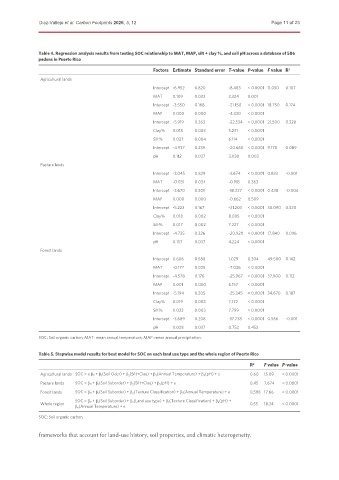
               Table 4. Regression analysis results from testing SOC relationship to MAT, MAP, silt + clay %, and soil pH across a database of 586
               pedons in Puerto Rico

                                                       Factors Estimate Standard error T-value P-value F value R 2
               Agricultural lands
                                                       Intercept -6.952  0.820   -8.483  < 0.0001 11.050  0.107
                                                       MAT    0.109  0.033       3.324  0.001
                                                       Intercept -3.550  0.168   -21.150  < 0.0001 18.750  0.174
                                                       MAP    0.000  0.000       -4.330  < 0.0001
                                                       Intercept -5.919  0.263   -22.534  < 0.0001 21.500  0.328
                                                       Clay%  0.018  0.003       5.231  < 0.0001
                                                       Silt%  0.027  0.004       6.114  < 0.0001
                                                       Intercept -4.937  0.239   -20.660  < 0.0001 9.178  0.089
                                                       pH     0.112  0.037       3.030  0.003
               Pasture lands
                                                       Intercept -3.045  0.829   -3.674  < 0.0001 0.833  -0.001
                                                       MAT    -0.031  0.034      -0.913  0.363
                                                       Intercept -3.670  0.201   -18.227  < 0.0001 0.438  -0.004
                                                       MAP    0.000  0.000       -0.662  0.509
                                                       Intercept -5.222  0.167   -31.203  < 0.0001 38.090  0.320
                                                       Clay%  0.018  0.002       8.005  < 0.0001
                                                       Silt%  0.017  0.002       7.227  < 0.0001
                                                       Intercept -4.735  0.226   -20.920  < 0.0001 17.840  0.096
                                                       pH     0.157  0.037       4.224  < 0.0001
               Forest lands
                                                       Intercept 0.606  0.588    1.029  0.304  49.500  0.142
                                                       MAT    -0.177  0.025      -7.036  < 0.0001
                                                       Intercept -4.578  0.176   -25.967  < 0.0001 37.900  0.112
                                                       MAP    0.001  0.000       6.157  < 0.0001
                                                       Intercept -5.194  0.205   -25.345  < 0.0001 34.670  0.187
                                                       Clay%  0.019  0.003       7.172  < 0.0001
                                                       Silt%  0.023  0.003       7.799  < 0.0001
                                                       Intercept -3.689  0.208   -17.738  < 0.0001 0.566  -0.001
                                                       pH     0.028  0.037       0.752  0.453
               SOC: Soil organic carbon; MAT: mean annual temperature; MAP: mean annual precipitation.


               Table 5. Stepwise model results for best model for SOC on each land use type and the whole region of Puerto Rico
                                                                                         R 2  F value P-value
               Agricultural lands SOC = o β0 + β 1 (Soil Oder) + β 2 (Silt+Clay) + β 3 (Annual Temperature) + β 4 (pH) + e  0.60  15.09  < 0.0001
               Pasture lands  SOC = β0 + β 1 (Soil Suborder) + β 2 (Silt+Clay) + β 3 (pH) + e  0.45  7.674  < 0.0001
               Forest lands  SOC = β0 + β 1 (Soil Suborder) + β 2 (Texture Classification) + β 3 (Annual Temperature) + e  0.598 17.66  < 0.0001
                           SOC = β0 + β 1 (Soil Suborder) + β 2 (Land use type) + β 3 (Texture Classification) + β 4 (pH) +
               Whole region                                                              0.55  18.34  < 0.0001
                           β 5 (Annual Temperature) + e
               SOC: Soil organic carbon.

               frameworks that account for land-use history, soil properties, and climatic heterogeneity.

