


Page 9 - 2417
P. 9
Corsini et al. Carbon Footprints 2026, 5, 34                                      Page 5 of 20


               Parametrization of the model
               The exponential decay model arises as the analytical solution of a first-order differential equation describing
               the proportional decay with distance, a property characteristic of diffusion-like ecological processes. As the
               exponential decay model is grounded in well-established mathematical properties of diffusion, attenuation,
               and boundary-driven processes, the parameters α and β are defined theoretically [35,42] .


               Within this formulation, parameters emerge from the mathematical structure of the differential equation and
               from ecological first principles that govern the structure and dynamics of the landscape, not from data
               calibration. This is consistent with mechanistic modeling in landscape ecology, where parameters are derived
               from theoretical descriptions of spatial propagation, edge influence, fragment geometry, and landscape
               resistance, rather than solely from empirical regression.


               Alpha (α): maximum distance of influence
               The parameter α represents the maximum spatial extent of degradation influence generated by surrounding
               deforestation. It is interpreted as the upper bound of edge-driven degradation pressure acting on the project
               area. Alpha is obtained from the following steps: (i) RR delineation; (ii) Building of a binary matrix with
               deforestation data; (iii) Computing a Euclidean distance surface; (iv) Estimation of the Weighted Landscape
               Class Proportion (PL ); and (v) Applying the equation to estimate the alpha.
                                w

               • Reference region delineation
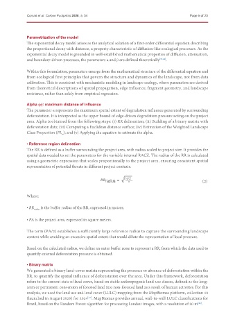
               The RR is defined as a buffer surrounding the project area, with radius scaled to project size. It provides the
               spatial data needed to set the parameters for the variable internal RACZ. The radius of the RR is calculated
               using a geometric expression that scales proportionally to the project area, ensuring consistent spatial
               representation of potential threats in different project contexts.

                                                              q
                                                         radius  =      /2                              (2)


               Where:

               • RR radius  is the buffer radius of the RR, expressed in meters;


               • PA is the project area, expressed in square meters.


               The term (PA/2) establishes a sufficiently large reference radius to capture the surrounding landscape
               context while avoiding an excessive spatial extent that would dilute the representation of local pressure.

               Based on the calculated radius, we define an outer buffer zone to represent a RR, from which the data used to
               quantify external deforestation pressure is obtained.


               • Binary matrix
               We generated a binary land-cover matrix representing the presence or absence of deforestation within the
               RR, to quantify the spatial influence of deforestation over the area. Under this framework, deforestation
               refers to the current state of land cover, based on stable anthropogenic land-use classes, defined as the long-
               term or permanent conversion of forested land into non-forested land as a result of human activities. For this
               analysis, we used the land use and land cover (LULC) mapping from the MapBiomas platform, collection 10
               (launched in August 2025) for 2024 . MapBiomas provides annual, wall-to-wall LULC classifications for
                                             [43]
               Brazil, based on the Random Forest algorithm for processing Landsat images, with a resolution of 30 m .
                                                                                                     [44]

