
Page 22 - Read Online
P. 22
Phadke et al. Intell Robot 2023;3:453-78 https://dx.doi.org/10.20517/ir.2023.27 Page 467
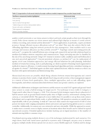
Table 5. Categorization of referenced study by the major resilience module/component they consider (target study)
Resilience component/module highlighted Referenced study
Area coverage [32,85,93,98-100,104]
Path planning [95]
Agent property (heterogeneity) [94,102-104]
Testbed design and resilience measurement metrics [97]
Resource allocation, optimization [85,92,97,99,100,103,105]
Task assignment/reassignment [84,98]
Network coverage, structure [94]
analyze crowd movements or use vision sensors to detect and track certain people as they move through the
crowd. Police drone swarms use vision sensors and onboard light displays as means of crowd control,
evidence recording, and criminal activity deterrents [90,91] . These applications, in particular, require persistent
[85]
presence. Energy-efficient resource allocations such as are ideal. They may also achieve this by task-
offloading algorithms using fast network protocols for data management. Joint modules such as area
coverage and resource allocation are thus actively covered [85,92] . Topology control and routing protocols,
such as in , recognize the tradeoff between area coverage and connectivity and provide solutions based on
[93]
modules that balance mission completion and communication. Target surveying may also be classified by
the size of the area being surveyed. Using UAV swarms to monitor traffic conditions and road bottlenecks is
one such perceived application . Current persistent schemes, as outlined in , are the replacement of
[94]
[34]
agents, novel team formation approaches, and energy-efficient behaviors for path planning. Individual
modules of swarm functioning, such as path planning, are ideal recipients of learning-based augmentation
methods to improve efficiency. A reinforcement learning-based algorithm performs centralized training on
all agents of a swarm . Individual agents can then make optimal decisions, while the swarm as a whole can
[95]
function with sparse information and historical map data.
Hierarchical structures are possible, which bring cohesion between swarm heterogeneity and control
schemes to produce better results. A high-altitude fixed-wing aircraft provides critical management support
to a swarm of lower-level quadcopters. Here, multiple approaches, such as task offloading, agent
heterogeneity, and robust communication links between swarm and ground controls, are explored.
Additional collaboration techniques exist between mobile sensors on aerial UAV agents and ground-based
static sensors to create a hybrid strategy for target search. This technique is more viable in Category 3:
Target search rather than in Category 2: SAR. This is because hybrid strategies require the pre-placement of
hybrid sensors such as ground-based mission pads, time-of-flight cameras, environment-sensing vision
cameras, or terrestrial LiDAR. This approach is more viable when it is possible to set up these static sensors
beforehand, such as agricultural fields, roads, or urban buildings. SAR operation scenarios are usually more
unpredictable, with no pre-planning. A study in uses such static sensors for target search of SAR of a lost
[96]
person but makes wide-ranging assumptions about each sensor and agent having global access to a central
controller. Additionally, the sensors are non-retrievable and non-relocatable. While the approach is sound,
it makes more economic sense to deploy sensors at locations where their benefit can be realized in typical
operational scenarios. Potential applications include tracking cars at signal junctions or the number of
animals entering fields to consume crops.
Distributed sensing using multiple drones is one of the techniques implemented for such scenarios. One
single drone fitted with varied sensor payload is expensive and, if damaged, can put a stop to mission
progress; multiple smaller drones spread over an area is a more flexible approach. Testbeds and the design