


Page 17 - 2417
P. 17
Corsini et al. Carbon Footprints 2026, 5, 34                                     Page 13 of 20


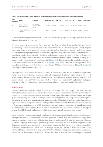
               Table 1. Test results for RACZ model application in landscapes with contrasting external pressure and internal resilience
               Case    Name            Country                              α (m) CI  k     β (m ) RACZ (ha)
                                                                                               -1
               study ID                              Area (ha) RR radius  (m) PL w
                                       Democratic
                       Kokolopori Bonobo
               1                       Republic of the  424,200  25,983  0.0008 719  0.61  0.0071 0.0043 1,150
                       Natural Reserve
                                       Congo
                       Indigenous Territory
               2                       Brazil        340,100  23,267  0.83  19,407 0.49 0.0055 0.0027 337,985
                       Parakanã
               correction factor applied to the initial α parameter was extremely high, producing a maximum external
               influence distance (α) of 19,407 m.

               The structural characteristics of the project area further modulate this spatial influence. Despite
               encompassing over 340,000 hectares, the site exhibits a shape factor of 0.49, reflecting a moderately irregular
               geometry with a relatively high perimeter-to-area ratio. Such configurations reduce the stability of interior
               habitats by increasing the proportion of forest areas exposed to edge influence. Under these conditions, the
               model estimated a decay rate of β = 0.0027 m , which corresponds to a slower decline of disturbance
                                                        -1
               intensity, i.e., higher external influence penetration, relative to the very large α. The result of applying the
               model to each point on the area's edge is shown in Figure 5B-2. The various overlapping buffers are merged
               and inserted into the area to generate the RACZ [Figure 5B-3]. When combined in the exponential decay
               formulation, the large α and relatively lower β produced a RACZ of 337,985 hectares [Figure 5B-2 and B-3],
               extending across most of the project area.


               This expansive RACZ reflects the ecological reality of a landscape under intense anthropogenic pressure.
               Disturbance does not dissipate quickly and edge effects penetrate deeply into forest interiors due to both
               strong external forcing and structural fragmentation. The resulting pattern demonstrates how the RACZ
               framework responds sensitively to the joint effects of pressure and susceptibility, capturing a broad spatial
               footprint of vulnerability in contexts where degradation is both pervasive and spatially far-reaching.


               DISCUSSION
               The two case studies demonstrate how degradation risk emerges from the complex interaction between
               external anthropogenic pressure and internal structural resistance, reinforcing the need for spatially adaptive
               approaches in conservation planning and carbon-accounting methodologies. In low-pressure landscapes,
               sparse surrounding deforestation and largely intact structure produced higher β values, reflecting rapid
               attenuation of disturbance signals and resulting in narrow RACZ bands around forest edges. Conversely, in
               high-pressure frontier regions dominated by fragmentation and repeated disturbances, lower β values result
               in slow decay rates and extensive RACZ footprints, capturing the deeper penetration of spatially contagious
               degradation processes. Together, these outcomes demonstrate the RACZ model's capacity to distinguish
               structurally stable forests from landscapes subject to pervasive, spatially contagious degradation.

               These contrasting patterns are aligned with long-standing expectations in landscape ecology. Fragments
               differ profoundly in their susceptibility to external pressures based on their size and shape [26,27] . Large, intact
               fragments maintain extensive core habitat and internal microclimatic stability, buffering external influences
               and producing steep, short-range degradation gradients. In contrast, small or irregular fragments exhibit
               disproportionately large perimeter-to-area ratios, increasing their exposure to temperature shifts,
               desiccation, wind turbulence, treefall rates, invasive species, and fire - leading to slower attenuation of edge
               effects and higher vulnerability to degradation [19,48] . The RACZ model operationalizes these mechanisms
               mathematically through the interaction of α and β:α describes the maximum spatial envelope in which risk

