


Page 27 - Read online
P. 27
Page 4 of 21                                               Artyukhov et al. Carbon Footprints 2026, 5, 8


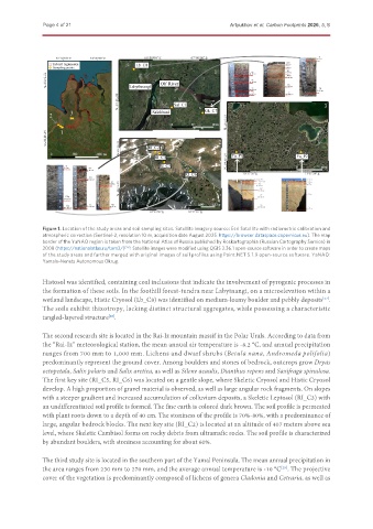
               Figure 1. Location of the study areas and soil sampling sites. Satellite imagery source: Esri Satellite with radiometric calibration and
               atmospheric correction (Sentinel-2, resolution 10 m, acquisition date August 2025. https://browser.dataspace.copernicus.eu). The map
               border of the YaNAO region is taken from the National Atlas of Russia published by Roskartographia (Russian Cartography Service) in
               2008 (https://nationalatlas.ru/tom3/) [26] . Satellite images were modified using QGIS 3.36.1 open-source software in order to create maps
               of the study areas and further merged with original images of soil profiles using Paint.NET 5.1.9 open-source software. YaNAO:
               Yamalo-Nenets Autonomous Okrug.


               Histosol was identified, containing coal inclusions that indicate the involvement of pyrogenic processes in
               the formation of these soils. In the foothill forest-tundra near Labytnangi, on a microelevation within a
               wetland landscape, Histic Cryosol (Lb_C8) was identified on medium-loamy boulder and pebbly deposits .
                                                                                                        [27]
               The soils exhibit thixotropy, lacking distinct structural aggregates, while possessing a characteristic
               tangled-layered structure .
                                    [28]

               The second research site is located in the Rai-Iz mountain massif in the Polar Urals. According to data from
               the “Rai-Iz” meteorological station, the mean annual air temperature is -8.2 °C, and annual precipitation
               ranges from 700 mm to 1,000 mm. Lichens and dwarf shrubs (Betula nana, Andromeda polifolia)
               predominantly represent the ground cover. Among boulders and stones of bedrock, outcrops grow Dryas
               octopetala, Salix polaris and Salix arctica, as well as Silene acaulis, Dianthus repens and Saxifraga spinulosa.
               The first key site (RI_C5, RI_C6) was located on a gentle slope, where Skeletic Cryosol and Histic Cryosol
               develop. A high proportion of gravel material is observed, as well as large angular rock fragments. On slopes
               with a steeper gradient and increased accumulation of colluvium deposits, a Skeletic Leptosol (RI_C3) with
               an undifferentiated soil profile is formed. The fine earth is colored dark brown. The soil profile is permeated
               with plant roots down to a depth of 40 cm. The stoniness of the profile is 70%-80%, with a predominance of
               large, angular bedrock blocks. The next key site (RI_C2) is located at an altitude of 407 meters above sea
               level, where Skeletic Cambisol forms on rocky debris from ultramafic rocks. The soil profile is characterized
               by abundant boulders, with stoniness accounting for about 60%.

               The third study site is located in the southern part of the Yamal Peninsula. The mean annual precipitation in
               the area ranges from 230 mm to 270 mm, and the average annual temperature is -10 °C . The projective
                                                                                           [29]
               cover of the vegetation is predominantly composed of lichens of genera Cladonia and Cetraria, as well as

