
Page 158 - Read Online
P. 158
Page 6 of 16 Kodag et al. Dis Prev Res 2023;2:12 https://dx.doi.org/10.20517/dpr.2023.11
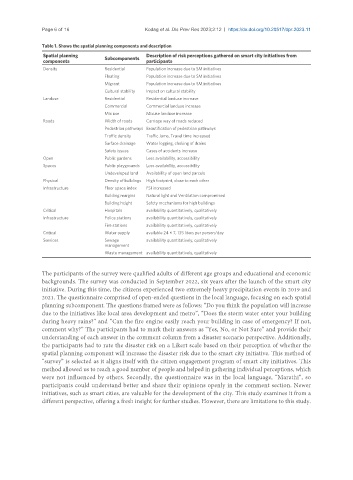
Table 1. Shows the spatial planning components and description
Spatial planning Subcomponents Description of risk perceptions gathered on smart city initiatives from
components participants
Density Residential Population increase due to SM initiatives
Floating Population increase due to SM initiatives
Migrant Population increase due to SM initiatives
Cultural stability Impact on cultural stability
Landuse Residential Residential landuse increase
Commercial Commercial landuse increase
Mix use Mixuse landuse increase
Roads Width of roads Carriage way of roads reduced
Pedestrian pathways Beautification of pedestrian pathways
Traffic density Traffic Jams, Travel time increased
Surface drainage Water logging, choking of drains
Safety issues Cases of accidents increase
Open Public gardens Less availability, accessibility
Spaces Public playgrounds Less availability, accessibility
Undeveloped land Availability of open land parcels
Physical Density of buildings High footprint, close to each other
Infrastructure Floor space index FSI increased
Building margins Natural light and Ventilation compromised
Building height Safety mechanisms for high buildings
Critical Hospitals availability quantitatively, qualitatively
Infrastructure Police stations availability quantitatively, qualitatively
Fire stations availability quantitatively, qualitatively
Critical Water supply available 24 × 7, 135 liters per person/day
Services Sewage availability quantitatively, qualitatively
management
Waste management availability quantitatively, qualitatively
The participants of the survey were qualified adults of different age groups and educational and economic
backgrounds. The survey was conducted in September 2022, six years after the launch of the smart city
initiative. During this time, the citizens experienced two extremely heavy precipitation events in 2019 and
2021. The questionnaire comprised of open-ended questions in the local language, focusing on each spatial
planning subcomponent. The questions framed were as follows: “Do you think the population will increase
due to the initiatives like local area development and metro”, “Does the storm water enter your building
during heavy rains?” and “Can the fire engine easily reach your building in case of emergency? If not,
comment why?” The participants had to mark their answers as “Yes, No, or Not Sure” and provide their
understanding of each answer in the comment column from a disaster scenario perspective. Additionally,
the participants had to rate the disaster risk on a Likert scale based on their perception of whether the
spatial planning component will increase the disaster risk due to the smart city initiative. This method of
“survey” is selected as it aligns itself with the citizen engagement program of smart city initiatives. This
method allowed us to reach a good number of people and helped in gathering individual perceptions, which
were not influenced by others. Secondly, the questionnaire was in the local language, “Marathi”, so
participants could understand better and share their opinions openly in the comment section. Newer
initiatives, such as smart cities, are valuable for the development of the city. This study examines it from a
different perspective, offering a fresh insight for further studies. However, there are limitations to this study.