
Page 34 - Read Online
P. 34
Chen et al. Intell Robot 2024;4:179-95 I http://dx.doi.org/10.20517/ir.2024.11 Page 183
processensuresthatonlypointsincludedinanarrowsegmentalongthehuman’swalkingdirectionareselected
to represent the terrain shape. Ground 2D is the set of 2D point ( , ) of which the index is in . Dimension
reduction is achieved by only involving the and coordinates in Ground 2D, which projects all the 3D points,
of which the indexes belong to , to the human’s sagittal plane. This preprocessing strategy, including point
cloud rotation, subset extraction and dimension reduction, leads to the conversion of the 3D data into a 2D
point cloud Ground 2D that is now represented within the ground coordinate system, which aims to lower the
computation burden when dealing with 3D point cloud data.
Ground
3D = {( , , ) | = 1, . . . , }
= { | − 0.1m < < 0.1m} (2)
Ground
2D = { ( , )| ∈ }
The process of point cloud registration for all points within the 2D point cloud set demands significant compu-
tational power from the hardware and may lead to prolonged processing times. In response to these challenges,
ourearlierwork [31] proposedtoextractfeaturedcornerpointsfromthe2Dpointcloudtolowercomputational
burdens and streamline the registration process.
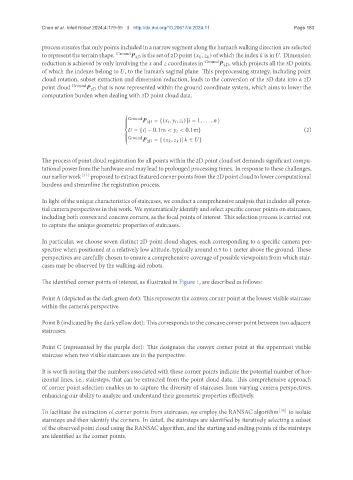
In light of the unique characteristics of staircases, we conduct a comprehensive analysis that includes all poten-
tial camera perspectives in this work. We systematically identify and select specific corner points on staircases,
including both convex and concave corners, as the focal points of interest. This selection process is carried out
to capture the unique geometric properties of staircases.
In particular, we choose seven distinct 2D point cloud shapes, each corresponding to a specific camera per-
spective when positioned at a relatively low altitude, typically around 0.5 to 1 meter above the ground. These
perspectives are carefully chosen to ensure a comprehensive coverage of possible viewpoints from which stair-
cases may be observed by the walking-aid robots.
The identified corner points of interest, as illustrated in Figure 1, are described as follows:
Point A (depicted as the dark green dot): This represents the convex corner point at the lowest visible staircase
within the camera’s perspective.
Point B (indicated by the dark yellow dot): This corresponds to the concave corner point between two adjacent
staircases.
Point C (represented by the purple dot): This designates the convex corner point at the uppermost visible
staircase when two visible staircases are in the perspective.
It is worth noting that the numbers associated with these corner points indicate the potential number of hor-
izontal lines, i.e., stairsteps, that can be extracted from the point cloud data. This comprehensive approach
of corner point selection enables us to capture the diversity of staircases from varying camera perspectives,
enhancing our ability to analyze and understand their geometric properties effectively.
To facilitate the extraction of corner points from staircases, we employ the RANSAC algorithm [30] to isolate
stairsteps and then identify the corners. In detail, the stairsteps are identified by iteratively selecting a subset
of the observed point cloud using the RANSAC algorithm, and the starting and ending points of the stairsteps
are identified as the corner points.