
Page 60 - Read Online
P. 60
Page 4 of 20 Huang et al. Complex Eng Syst 2023;3:2 I http://dx.doi.org/10.20517/ces.2022.43
Figure 1. The coordinate system of the vehicle.
Figure 2. Lane detection data.
map are discussed. We use a numerical integration method to calculate the parametric curve arc lengths. In
this way, the parametric scale equidistant curves are transformed into arc-length scale middle curves, making
the curve structure more uniform.
The third part is a fusion localization method based on HD maps and odometry. A method for feature associ-
ation between current HD map information and the camera’s real-time perceptual features is investigated. A
respective similarity evaluation metric is formulated for different essential elements in the HD map. Accord-
ing to the accumulated confidence smoothing, the results are smoothed on the time scale and converted into a
graph optimization problem. Finally, the amount of computation for graphics optimization is reduced using
a sliding window method and improved keyframe selection.
The KITTI dataset is used for autonomous driving and mobile robot research [29] . This study uses only camera
2 and the synchronized and corrected data in the KITTI dataset. Therefore, we add some definitions based
on KITTI’s original definitions. Taking camera 2 as the origin to establish a camera coordinate system, the
intersection of the vertical line from the midpoint of the front and rear axles of the vehicle (the middle of the
four wheels) to the ground and the ground is taken as the vehicle center point, and the base_link coordinate
system is established. The positive direction of the -axis is forward along the vehicle’s driving path, the -
axis points to the left side of the vehicle’s driving direction, and the -axis is vertical upward. The vehicle’s
coordinate system is shown in Figure 1.
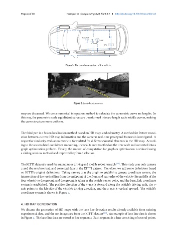
4. HD MAP GENERATION
We discuss the generation of HD maps with the lane line detection results already available from existing
experimental data, and the test images are from the KITTI dataset [29] . An example of lane line data is shown
in Figure 2. The lane line data are stored as line segments. Each segment is a lane consisting of several points.