


Page 99 - Read Online
P. 99
Page 14 of 23  Yu et al. Carbon Footprints 2025, 4, 17  https://dx.doi.org/10.20517/cf.2025.12


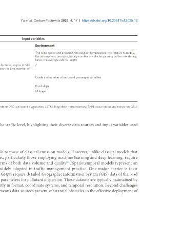
 Table 4. Representative studies using time-series models for vehicle-level emission estimation

                Input variables
 Reference  Model  Data source  Dynamic driving
 behavior  Vehicle attribute  Environment
 [72]  Wavelet   Remote CO    Speed, acceleration  /  The wind speed and direction, the outdoor temperature, the relative humidity,
 2
 transform,   sensor, LPR data   the atmospheric pressure, hourly number of vehicles passing by the monitoring
 LSTM                   lanes, the average vehicle length
 [73]  LSTM, RNN,   Dynamometer test  Speed  Engine family, engine manufacturer, engine model   /
 GRU  data  year, vehicle inertia, odometer reading, number of
 cylinders, fuel type
 [74]  LSTM  GPS, PEMS,   Speed, acceleration  /  Grade and number of on-board passenger variables
 passenger data
 [75]  LSTM  PEMS, GPS  Speed, acceleration, VSP  /  Road slope
 [76]  RNN, LSTM  CO2 sensor, OBD  Speed, acceleration,   /  Mileage
 engine RPM, fuel flow,
 throttle

 LPR: License plate recognition; PEMS: portable emissions measurement system; GPS: global positioning system; OBD: on-board diagnostics; LSTM: long short-term memory; RNN: recurrent neural networks; GRU:
 gated recurrent unit.


 Table 5 summarizes several representative spatiotemporal emission models at the traffic level, highlighting their diverse data sources and input variables used
 to capture the complex spatiotemporal dynamics of traffic emissions.


 Discussion
 Data requirements
 The data requirements for data-driven emission models are broadly comparable to those of classical emission models. However, unlike classical models that

 typically rely on predefined emission factor databases, data-driven approaches, particularly those employing machine learning and deep learning, require
 independent model training. This entails substantially higher demands in terms of both data volume and quality . Spatiotemporal models represent an
                                             [82]
 emerging paradigm in traffic emission modeling, yet they have not been widely adopted in traffic management practice. One major barrier is their
 exceptionally high data requirements. For instance, models based on GNNs or GNNs require detailed Geographic Information System (GIS) data of the road

 network, high-resolution dynamic traffic flow information, and meteorological parameters for pollutant dispersion. These datasets are typically maintained by
 different government agencies or private entities, and they often vary significantly in format, coordinate systems, and temporal resolution. Beyond challenges
 in data acquisition, low data quality and the complexity of integrating heterogeneous data sources present substantial obstacles to the effective deployment of

 spatiotemporal emission models in real-world road networks.

