
Page 12 - Read Online
P. 12
Page 318 Lei et al. Intell Robot 2022;2(4):31332 I http://dx.doi.org/10.20517/ir.2022.18
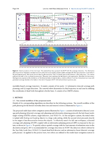
Figure 3. Overall procedure of the multi-layer. The dashed blue lines represent the DCPP with the coverage directions. The informative
planning protocol integrates coverage directions and continues to rapidly achieve spatial coverage with the least estimation uncertainty in
the decomposed grids. Red circles are the dead broilers found by YOLO V4-based dead broiler detector in the boiler barn. The maroon
grids are the hubs in the row-based environment. The green lines represent the hub-based multi-target paths. Note that the heat map in
this figure only represents the distribution of the historical data of dead chickens, which is different from the information heat maps with
generated coverage direction information in the rest of the paper. DCPP: Defined contribution pension plan.
mortality-based coverage trajectory. It mainly consists of two parts: (1) informative directed coverage path
planning; and (2) target detection. The removal robot determines the final trajectory in real time by utilizing
the coordinates of dead birds throughout a broiler barn. It consists of an HMTR scheme.
3. METHOD
3.1. The overall workflow of the proposed work
Details of the corresponding algorithms are described in the following sections. The overall workflow of the
path planning for the broiler mortality detection and removal robots is illustrated in Figure 4.
The proposed multi-layer robot navigation system illustrated in Figure 4 consists of informative directed cover-
age path planning (directed coverage path planning and informative planning protocol), the hub-based multi-
target routing (HMTR) scheme, target detection, and YOLO V4. In this navigation system, the initial robot
is tasked with finding and locating objects in a large-scale setting, while the second robot proceeds directly
to the targets it has discovered to remove the objects. To effectively search the full vast workspace, a directed
coverage path planning (DCPP) coupled with an informative planning protocol (IPP) is proposed in the sys-
tem, as shown in Figure 4. To quickly achieve spatial coverage with the least amount of estimation error in the
deconstructed grids, IPP is recommended for coverage directions in DCPP. The detection robot is driven by
the You Only Look Once (YOLO) V4-based dead bird detector and an informative-based directed coverage
path planner. As applied in the poultry barn, two robots are utilized in this multi-layer navigation system to